North, south, west, east - the location of geographical directions can be determined by a mobile phone, a magnetic compass, and nature itself. It is impossible to exclude a situation when the necessary objects to help you find out the directions of the world are not nearby, and you will have to find the path yourself. There are guidelines that travelers need in every possible situation.
Orientation without a compass
Learning to navigate a backpacking trip is extremely important, especially in sparsely populated and unfamiliar areas. This will help you not get lost and survive. In addition, the accuracy of following the laid route and achieving the goal depends on the correct choice and skillful use of various methods and techniques to navigate the area.
Sunny skies make it easy to navigate the terrain
There are different ways to determine one side or another:
- Classical methods include a compass and a map.
- Among modern methods, topographic maps are popular. They help define a large area. Ground navigation devices help determine the terrain and follow the laid route.
A magnetic compass is considered one of the simplest navigation devices, but quite often you have to operate without a map and compass. In this case, the stars, the sun and various natural phenomena will help you.
LUsing a classic compass: The ABCs of orientation - how to use a tourist compass
LOriginal method in the absence of a map: Orientation by sound - advantages and disadvantages of the method
Temples are a reliable landmark
If you can see church domes in the distance, pay attention to the location of the crosses, since churches are built with orientation towards the sides of the horizon. The upper end of the lower crossbar of the Orthodox cross is directed to the north, the lower end to the south.
An entrance will be installed on the western side and a bell group will be installed. The altar is traditionally located in the eastern part of the building. These rules apply to Orthodox churches. In Lutheran and Catholic churches, the altar is located on the west side.
Synagogues are built with an orientation toward Jerusalem, Muslim mosques toward Mecca.
But you can find out the sides of the horizon from the synagogue and mosque by the location of the entrance: it is always located from the north.
Method for determining the cardinal directions using the cross of the Orthodox Church.
How to determine cardinal directions by the sun
If you go hiking without any navigation, the first thing that will help you not get lost is the sun. At dawn it is located on the eastern side, and at sunset it moves to the west. Face it at sunrise: you will have north on your left, south on your right, and west on your back.
Sun orientation
This determination method is one of the simplest and most frequently used, although it does not provide 100% accuracy. It is almost impossible to determine your location using the sun when it is cloudy outside. In addition, there are a number of other nuances:
- our country is located in the northern hemisphere, here the sun rises from the eastern side and sets from the western side exclusively on March 21 and September 23;
- in spring and summer its position is slightly shifted to the north, with the approach of the winter period - to the south, on June 21 - to the northeast and northwest, on December 21 - to the southeast and southwest.
Watch
We place the device on a horizontal place so that the arrow points to the celestial body. Next, we divide the angle formed between the number twelve and the arrow into two equal parts. The line in the middle will point south.
Orientation by clock
If you want to determine the accuracy of your location before lunch, you need to divide the sector with the hour hand that passed before 13:00. After noon we divide the arrow that passed after 13:00.
Shadow
Take a long stick about 0.5 m long and drive it into the ground. Next, you need to watch how the length of the shadow changes until it becomes very short. This is a sign that the sun is at its zenith and the shadow points north.
Stick and stone
The method is similar to the previous one - first we stick a stick into the ground, and place a pebble or any other heavy object on the tip of the reflective shadow. After 15 minutes, we make another mark and connect both stones with a stick. The first pebble will point to the east, and the second to the west. Next we place another stick perpendicularly. In the place where the shadow casts there will be south, on the contrary - north.
LYou can also tell the time by the luminaries. How? Read here: How to find out the exact time without a watch while hiking
Directional designations
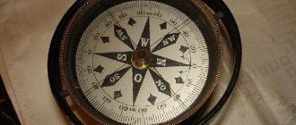
by letters on the compass accepted throughout the world , which are understandable to any inhabitant of the globe, but Russian-language letters are also possible.
- The northern direction is denoted by the Latin letter N (in Latin - north) or the Russian letter - C (that is, “north”).
- The southern direction is shown by the Latin S (in this ancient language - south) or our Yu (that is, “south”).
- The eastern direction is marked with the Latin E (in Latin - east) or the letter B of the Russian alphabet (that is, “east”).
- The Western direction corresponds to the Latin W (west in Latin) or the Russian Z (that is, “west”).
Salting (that is, clockwise) it looks like this: at the top - N (or our C - “es”), further on the right side of the limb is located - E (or our “in” Below - S or our Yu, on the left - W or our Z.
Landmarks for the directions of light, both for maps and globes, and for compasses and terrain, will be placed identically:
- if you position yourself facing north, the north pole will be in front;
- the south pole will be behind;
- the eastern direction will be located on the right hand;
- western - on the left hand.
It is important to understand that the compass, due to the presence of magnetic declination, does not indicate directions one hundred percent correctly! The compass error determines the magnetic declination.
Whereas the instrument indicates geographic light directions, they will actually be offset to some small extent by some amount in degrees . Since the geographic and power poles of the earth do not coincide, it is necessary to make corrections when accurately calculating the azimuth before the upcoming long route. If the expected path is not very long, and the magnetic declination does not exceed 10 degrees, then it makes sense to do without corrections.
Declination is mainly indicated outside the map fields for a specific area. If this is not indicated, it can be found in the reference book - magnetic observatories regularly update the magnetic declination values in degrees that are typical for a particular area.
Finding North and South by the moon
Moon in the sky
To accurately find the direction you need, you should know all the phases of the moon:
- In the first quarter it grows, so its tips will be directed to the left. At 7 pm the moon will be in the south, and at 1 am it will move to the west.
- There is a full moon in the second quarter. By 7 o'clock in the evening the heavenly body will be visible in the east, and after midnight - in the south.
- In the third phase, when the moon is waning, the horns of the month are turned to the right. At one o'clock in the morning it will be in the east, and by seven o'clock in the morning it will be in the south.
Another important point is how to determine the direction of the world on a moonless night, when clouds have eclipsed the moon. Take a closer look at the tree trunks - on the side where the moss grows, there will be north. You can determine the south by the anthill. As a rule, it is located on the south side of the tree.
Near East
The word “east” is used as a contrast to the countries of Western Europe. From a geographical point of view, countries belonging to the Middle East are not located in the East in relation to Europe.
The historical name of the Middle East is given to a large region of Asia and North Africa. It includes 17 countries inhabited by Armenians, Arabs, Turks, Kurds, Assyrians, Persians, Jews and other nationalities. For the most part, these are representatives of Islam, but there are also many Christians, Jews, Druze and Yazidis.
These areas are of strategic importance, as large hydrocarbon deposits are located here. The Middle East is a zone of constant military conflicts. This is a politically unstable area, since it is here that the Israeli-Palestinian conflict, the wars in Iraq and Syria are taking place, and the problematic Afghanistan is located. It is from the Middle East that Islamic extremism spreads.
North and South according to the starry sky
Don't worry if you get lost in the dark; several effective methods will help you find your way around without a compass.
polar Star
Since childhood, we have known about the existence of the North Star, which stands out among the many small lights in the sky. It is located in the constellation Ursa Minor.
Orientation by the stars
The North Star is located at the very top and has a bright light. It points north, but only if you are looking directly at it. Accordingly, the western side will be on your right, the eastern side on your left, and the southern side behind you.
Constellation Cassiopeia
Outwardly, it resembles the letter “M” when high in the sky, and the letter “W” when low above the horizon.
Cassiopeia
This constellation revolves around the North Star. The outermost and lowest star from the letter “M” is located at the same distance as the Big Dipper’s bucket.
South Cross
This method of determining terrain is only effective if you are in the southern hemisphere. Finding the Southern Cross constellation is not difficult. It appears in the shape of a cross and consists of four stars.
Correct definition of the Southern Cross
You will need the long part of the figure, its axis or the so-called pointer. We take the lower part of the axis as a basis, draw five segments from it equal in length to the axis. The end point will be in a southerly direction.
Far East of Russia
This region occupies 34% of the country's territory. It includes the Primorsky, Kamchatka and Khabarovsk territories, the Chukotka Autonomous Okrug, the Republic of Sakha-Yakutia, the Jewish Autonomous Region, the Amur, Magadan and Sakhalin regions.
The region of the Far East is predominantly mountainous and seismic. The Pacific coast is prone to cyclones and tsunamis. There are active volcanoes on the Kamchatka Peninsula, the most active of which is Klyuchevaya Sopka. This area is rich in mineral resources: gold, nickel, tin, mercury, manganese, tungsten, polymetallic ores, brown and hard coal, oil and gas. Mineral resources have been explored, but practically untouched.
The area is sparsely populated, with 7 million people living in a vast area larger than Western Europe. This is mainly due to inaccessibility. Development of the northern regions is currently not possible. Most of the Russian Far East belongs to the Far North regions.
Navigating natural phenomena without a compass
There are several more simple ways to determine the cardinal directions without a compass.
- Lichens and mosses. They generally prefer to grow on the north side of the wood of living and dead trees.
- For lost tourists in the mountains, one simple rule applies: in the south, on the northern side of the mountains, coniferous trees predominantly grow, and on the southern side, deciduous trees.
- In the sultry heat, you can determine the location by looking at the resin on the bark of coniferous trees. Such discharge appears on the south side of the wood.
- Mushrooms. As a rule, they grow on the north side of trees.
- Sunflower heads are always turned to the east.
- Soil moisture. You need to look at the soil near the stones. In the summer, it will be more humidified on the north side.
- Rings on a stump. As a rule, the center of the rings on the trunk cut is shifted to the north.
- Snow melts faster on southern slopes, forming notches directed to the south.
- The altars of Orthodox churches, Lutheran kirks and chapels always face east, and the main entrances are located on the west side.
L You can also find out the weather by natural phenomena: Ways to find out the weather by signs for tomorrow
Tags
determine the cardinal directions.which side blowsDetermining the cardinal directionsDefining the cardinal directionsDetermining the cardinal directionsThe opposite side isDetermining the cardinal directionscardinal directions.cardinal directions cardinal directions cardinal points cardinal points cardinal points cardinal points byHow to determine the cardinal directionsHow to determine the cardinal directionsto determine.1. We determine the parties; an approximate definition of the parties. Determination of the parties.
reply article commentsanthilldaysdonehikinggeographyapartmentrecordstourismexcursions
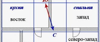
The relative position of the main and intermediate sides of the horizon
There are main directions - north, south, west, east - which are supplemented by intermediate ones. This division is very convenient; it allows you to more accurately determine the location on the ground, find objects on maps and topographic plans. For example, northeast is the side of the horizon located between the direction of north and east. On maps, plans, dials, in textbooks, reference books, designations are introduced using the first letter of the Russian or Latin name. There is a more detailed division of the sides of the horizon. Thus, between the directions from and north to east there are north-northeast (neast) and east-northeast (east).
Compass by PixelProse SARL
The multifunctional online compass from Google Play from PixelProse SARL does not contain any advertising in its free version. It provides the user with the following options:
- If you want to find an unfamiliar place, enter its address or name into the search. The app will then show you where it is.
- The program can even provide the shortest route to a user-specified location.
- The built-in qibla compass will help you correctly determine the direction in which the Kaaba is located in Mecca for Muslim rituals.
- You can save locations in the application memory to facilitate subsequent searches. You can even keep lists of your favorite addresses and attractions, organized by topic or category.
The accuracy of the readings is verified using GPS. The app also shows the altitude as well as the latitude and longitude of your current location.